New Zealand Maps
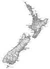
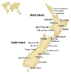
New Zealand is in the Southern Hemisphere and lies in the south-west of the Pacific Ocean. It is comprised of two major Islands (North and South) and a number of lesser islands, the largest of which is called Stewart Island.
The country is approximately 1,600 kilometres in length and the total land area is 270,000 square kilometres. The coastline has a length of 15,134 kilometres.
New Zealand Large Travel Map - Only NZ$19.95 - Free delivery worldwide.
New Zealand Compact Travel & Touring Map - Only NZ$13.95 - Free delivery worldwide.
KiwiMaps New Zealand Travellers Road Atlas - Only NZ$49.95 - Free delivery worldwide.
North Island Complete Drivers Atlas - Only NZ$49.95 - Free delivery worldwide.
South Island Complete Drivers Atlas - Only NZ$49.95 - Free delivery worldwide.
Other New Zealand Travel Options
Maps of New Zealand
PDF Map of NZ

Click map to download
NZ Cities and Towns

Click map to view.
Detailed Map of NZ
Click the region to view.
New Zealand is a relatively mountainous nation with ranges in both the North and South. The Cook Strait, 20 kilometres wide at its narrowest point, separates the two major islands. After the North and South Island, the next largest island is Stewart Island, which is 30 kilometres south of the South Island across Foveaux Strait.
Region Map of New Zealand
Click a region to view accommodation, attractions, tours, transport, visitor information and more for that NZ region.

New Zealand Driving Routes
Find a driving route for your New Zealand holiday here: your best-fit driving route is only a few clicks away. Sit back in the driver's seat and navigate your way to a holiday that exactly fits your interests, then print a hard copy of your New Zealand driving directions to guide you while you're on the road...(more)
Available New Zealand Driving Routes: Auckland, Wellington, Christchurch, Rotorua, Lord of the Rings, Specialised
Free Topographic Maps
Official New Zealand Topographic Maps available for free online through the new website www.nztopomaps.com
The online service allows users to quickly find, view and print topographic maps for planning recreational, business and research activities, and includes a place name search function. www.nztopomaps.com provides fast and simple access to the 'NZTopo' Topographic Map Series, which are traditionally purchased as printed paper maps.
The 'NZTopo' Topographic Map Series, produced by Land Information New Zealand (LINZ), is used for a variety of recreational activities such as tramping and fishing, and by businesses and government entities such as the Department of Conservation. Topographic maps are also an essential tool for defense planning, location and routing services, and land management.
The service is also available on smartphones such as iPhone devices, and makes use of their in-built GPS capabilities. Screen shots from an iPhone to demonstrate the use of www.nztopomaps.com on a smartphone are available from our media resources page at www.nztopomaps.com/media/.
Need a New Zealand map for your website? - Try our FREE Maps


